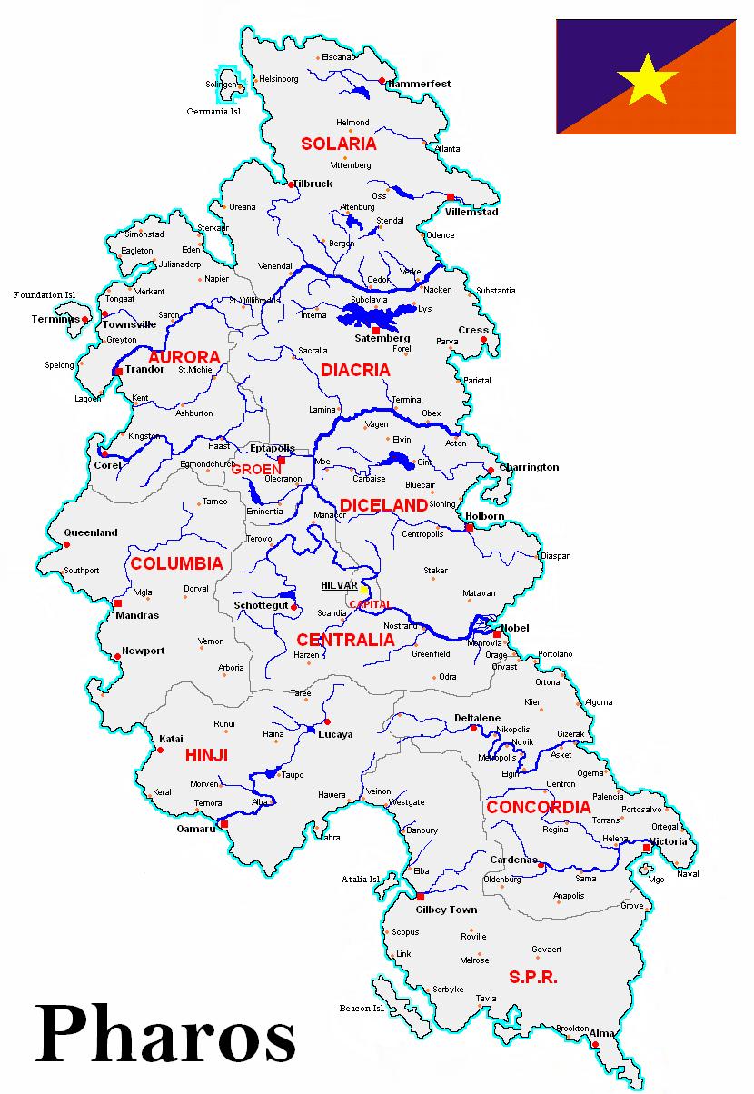
Geography
 Pharos is a large island in the North Atlantic Ocean. It has a total area of 78,095 km² (30,152 sq. mi) and a population of about 12.3 million (12,345,776 -2005 census). The island is located at the northernmost and highest point of the Atlantic Ridge. It is located to the west of the North Atlantic Current, which pushes eastwards towards Ireland. As a result, the island's southern and eastern shores experience a warmer climate than its northern and western shores. The latter experience the effects of the Irminger Current and have a sub polar oceanic climate.
There is a persistent area of low pressure to the northwest of Pharos, aptly named the Pharonian Low. Generally speaking, wind speeds tend to be higher in the Northwestern shores, but topographical features can aggravate winds and cause strong gusts in the Southeastern regions. Wind speed frequently reaches 18 m/s; on stormy days it averages 50 m/s. The inhospitable weather conditions have effected significantly the establishment of colonists and, in the Antiquity, the island was considered a place that was both dangerous to reach and impossible to inhabit.
Rocks and soil types
The island itself is composed primarily of basalt, the low-silica lava associated with effusive volcanism, typical of mid-ocean regions. These formations, in addition to their geo-morphological interest (as rich deposits of ores), are homes to a rich biodiversity of plant and animal life.
The eastern and western lowland is of limestone covered with glacial deposits of clay and sand, with widespread ponds and lakes. Lake Diacria and Gint Lake are two of the largest lakes. The central mountains vary greatly in geological structure. In the south, the mountains are composed of old red sandstone with limestone river valleys. In the central area, mainly in Centralia and Columbia the rocks are mainly of basalt, rich in ores deposits. In Aurora and Solaria, the mountains are mainly granite, while much of the northeast of the country is a basalt plateau. The basalts were originally part of the great Thulean Plateau formed during the Paleocene period.


The soils of the north and west tend to be poorly drained peats and gleys, including peaty podzols. In contrast, in the south and east the soils are free-draining brown earths and brown and grey-brown podzols. This is reflected in the rainfall distribution on the island, with the poorly drained regions being those with the highest rainfalls.
Mountain ranges
Pharos is divided along its length by the Monteneros Mountains or just "The Mountains", which are the most definite feature of the country. The Mountains have naturally divided the island in physical as well as traditional regions, states and counties. There are 7 main mountain ranges, running from north to south, with peaks ranging from 1,500 to 3,000 meters, highest of which is Hailin at 3,897 meters (12,730 feet) above sea level, located at the triple joint border of Centralia, Columbia and Hinji.

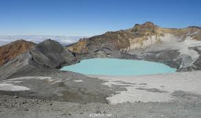
Starting on the northern part of Solaria, there is the Yrkan Mountain range, of low elevation. Its' highest peak is the only active volcano of the island, the Elscanab volcano (1,657 meters), within the Yrkan National Park.


The mountain chain swings eastwards, moving to the south along the Gerberg depression and to the southeast, forming the Ankar mountain range, the highest in Solaria, including 3 major peaks: Nadin (2,257 meters), Samtal (2,202 meters) and Gent (2,083 meters). The mountains then follow the border in an easterly direction reaching the Solaris River - the natural border with Diacria - where they become mostly gently sloping plateaus.
Passing the Solaris river to Diacria, the Zigoreth mountain range lies in northwestern Diacria to the direction of Lake Diacria eastwards, with Zudelink (2,123 meters) its' highest peak.
The Dariban - Santani mountain range is the natural border of Aurora and Diacria, with relatively high peaks, the highest being Amaronap (2,531 meters - 7,288 feet).

After the elevated Eptapolis plateau, there starts the Synnax mountain range (Synnax is also the name of its highest peak at 3,331 meters - 10,881 feet) at the Groen, Columbia and Centralia border. In the very centre of the island the Mountains divide into two ranges, one southwest forming the Orsa mountain range in eastern Columbia and one - the main core of the Monteneros Mountains - the Glyptal mountain range in Centralia, where most of the Mountains' highest peaks are located, such as Hailin, Obion (3,611 meters - 11,796 feet), Naika (3,501 meters - 11,436 feet), Anau (3,257 meters - 10,639 feet) and Nedas (3,121 meters - 10,195 feet).


Finally, in the southern part of the island lies the Elikon mountain range along the Concordia-SPR border, of much lower heights (Romount is the highest peak at 2,023 meters - 6,608 feet).
Rivers and lakes
Water comes in abundance in Pharos. There are several rivers, almost all emerging from the central mountain area, with the majority of them going eastwards and a lot, mainly smaller ones flowing to the western shores.The River Solaris is the natural border which divides Solaria from Diacria and has its origin from the Zigoreth Mountains. A number of tributaries, mainly on its northern side flow into the river, such as Lokris, Impro, Cuyk, Trot and Telveen. The River Isar (Isavrus) and the River Vaal (Valas was its original name) flow westwards in Aurora, originating from the Dariban-Santani Mountain range. The Isar is located in central Aurora and flows into the Trandor bay, as the Vaal River is further south and meets the ocean at Corel gulf. Another smaller in length and quantity of water river, the Tamanar River flows towards Kent in central Aurora.


The River Amadeus (ancient Aesis river, its' current name was given to honor the great composer Amadeus Mozart) rise from two main reservoirs, the Springs Lake in western Groen and the Aesis Pot, a small pool at the slopes of Synnax Mountains at the borders of Groen and Centralia. It flows northeastwards and is the natural border of Diacria and Diceland. De Graaf River is its main tributary, emerging from the southern slopes of the Zigoreth Mountains. From the same mountain range, only from the western slopes, rises a smaller river, the River Mosel (or Mosa as it was known in Antiquity), which goes west, ending in Mandras. It is the only body of water in Columbia. In Diceland to the east there are a number of small rivers, such as Natima, Billy and Daquebe.

The River Del Rey, named after the famous doctor Lester Del Rey (its' ancient name was Ollius or Oelus), the islands' longest river, originates from the Glyptal Mountains, flows to the east, passing through Schottegut and the country's capital Hilvar and forms his large delta northern of Nobel. Rikel and Staedler are its main tributaries.

From the southern slopes of the Glyptal mountain range, the River Timaru (name given by the Maori to the Mur or Murus river) flows into the Hinji valley, following a south, south-western direction towards Oamaru, as the River Aragon (old name Aranyos and later Arar) follows the opposite direction eastwards to Gizerak bay. Finally the River Tithonius and its main tributary Telstar have their springs in Elikon Mountains in Concordia and end up in Victoria.


Lake Diacria is the largest lake of the island. Legend has it that a giant in the North was fighting with another in the South, and enraged, scooped out a lump of earth, which he threw. It fell into the Iolian Gulf, creating the Isle of Atalia, while the hole filled up with water to become Lake Diacria. Other large lakes include Gint Lake (ancient Genusus Lake) in Diceland, Troll Lake in Solaria, Araora or Hinji Lake in Hinji and Springs Lake (ancient Nura Lake) in Groen.


Islands
There are 5 smaller islands off Pharos' coasts which are inhabited. Beacon Island in the south west is the largest. The other four are Foundation Island, off the Aurora coast, Vigo Island in the Victoria gulf, Germania Island in northwestern Solaria and Archon or Atalia islands in the Iolian gulf. All 5 islands are inhabited and are connected with the mainland with bridges. There are also several smaller islands and rocks around the main island that are uninhabited. The city of Corel is also situated on an island, Lisl island, but the Vaal delta residues has over the time connected the island to mainland.
Flora and fauna
As Pharos was isolated from mainland Europe by rising sea levels after the ice age, it has less diverse animal and plant species than either the British Isles or mainland Europe. There are around 1,300 known species of insects in Pharos, which is a rather low number compared with other countries (over one million species have been described worldwide). The only native land mammal when humans arrived was the Arctic Fox, which came to the island at the end of the ice age, walking over the frozen sea. Polar bears have also showed up through the history, yet they are just visitors, and no Pharonian population exists. There are no native or free living reptiles or amphibians on the island, except for the common lizard.
There are 55 mammal species in Pharos and of them only 26 land mammal species are native to the island. Some species, such as the red fox, hedgehog and badger, are very common, whereas others, like the Pharonian hare, red deer and pine marten are less so. The most common animals of Pharos include the Pharonian sheep named "eeb", cattle, chicken, goat, the sturdy Pharonian horse, and the Pharonian sheepdog.


Aquatic wildlife, such as species of turtle, shark, whale, and dolphin, are common off the coast. Many varieties of fish live in the ocean waters surrounding Pharos, and the fishing industry is a main contributor to the island's economy. Birds, especially seabirds, are a very important part of Pharos' animal life. Puffins, skuas, and kittiwakes nest on its sea cliffs. About 400 species of birds have been recorded in Pharos. Many of these are migratory, including the Barn Swallow. Most of Pharos' bird species come from Iceland, Greenland and Africa. The characteristic bird of the island is the Udbin bird, a kind of seagull.

Several different habitat types are found in Pharos, including farmland, open woodland, temperate broadleaf and mixed forests, conifer plantations, peat bogs and a variety of coastal habitats. However, agriculture drives current land use patterns in Pharos, limiting natural habitat preserves, particularly for larger wild mammals with greater territorial needs. With no top predator in Pharos, populations of animals, such as semi-wild deer, that cannot be controlled by smaller predators, such as the fox, are controlled by annual culling.
Phyto-geographically, Pharos belongs to the Sarmatic mixed forestsecoregion within the temperate broadleaf and mixed forests Biome, according to the World Wide Fund for Nature classification. Characteristic dominant broadleaf trees in Pharos include oaks, beeches, maples, and birches. The term "mixed forest" comes from the inclusion of coniferous trees as a canopy component of these forests. Typical coniferous trees in the island include pines, firs and spruces.
Permanent human settlement greatly disturbed the isolated ecosystem of thin, volcanic soils and limited species diversity. The forests were heavily exploited over the centuries for firewood and timber. Deforestation caused a loss of critical topsoil due to erosion, greatly reducing the ability of trees to grow back. The planting of new forests has increased the number of trees, but does not compare to the original forests. Some of the planted forests include new foreign species.

Climate
Pharos' climate is temperate, though significantly warmer than almost all other locations at similar latitude, such as Newfoundland, due to the warming influence of the North Atlantic drift. The prevailing wind blows from the southwest, breaking on the high mountains of the west coast. Rainfall is therefore a particularly prominent part of western Pharonian life, with Foundation Island, off the west coast of Aurora, getting almost twice as much annual rainfall as Nobel on the east (1,400 mm/55.1 in vs. 762 mm/30.0 in). Across the country, about 60% of the annual rainfall occurs between August and January.

There are some variations in the climate between different parts of the island. Generally speaking, the south coast is warmer, wetter and windier than the north. Low-lying inland areas in the north are the most arid. Snowfall in winter is more common in the north than the south (there is ca. 50% chance of a white Christmas in Alma or Gilbey Town but ca. 70% in Villemstad or Satemberg). Temperature ranges in winter from -10 °C to +10 °C and in the summer from +10 °C to +30 °C. The highest air temperature recorded was 38.5 °C on 22 July 1939 at Alma. The lowest was −28 °C on 22 January 1918 at Helsinborg.
January and February are the coldest months of the year, and mean daily air temperatures fall between 4 and 8 °C (39.2 and 47.2 °F) during these months. July and August are the warmest, with a range of 14 to 22 °C (60.2 to 71.6 °F). The sunniest months are May and June, with an average of six to eight hours sunshine per day. Though extreme weather events in Pharos are comparatively rare when compared with other countries in the European Continent, they do occur. Explosive Atlantic depressions, occurring mainly in the months of December, January and February, can occasionally bring winds of up to 160 km/h/99 mph to Western coastal counties; while the summer months, and particularly around late July/early August, sudden and violent thunderstorms can develop, more especially, but not exclusively, across midland and western areas of the country.